| |
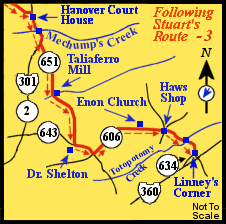
Route
(in red)
from Hanover Court House,
upper left, to Linney's Corner, lower Right.
Following the Route Numbers:
From Totopotomy Creek continue down Route 606 for approximately one mile to
its intersection with Route 634. This is Linney's Corner.
|
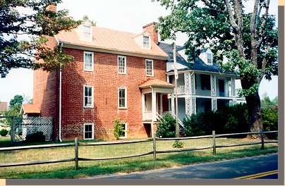
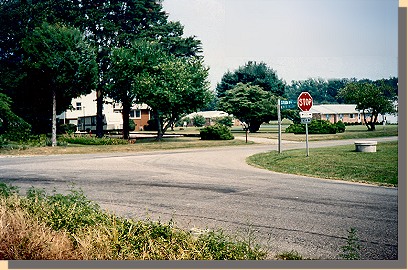 (M) (M)
Linney's Corner.
Where Captain Latane was killed.
... On, on dashed Robins [ Ninth Virginia Cavalry adjutant Lieutenant
Robins ], here skirting a field, there leaping a fence or ditch, and clearing
the woods beyond, when not far from Old Church the enemy made a stand, having
been re-enforced.
The only mode of attack being in column of fours along the road, I still
preferred to oppose the enemy with one squadron at a time, remembering
that he who brings on the field the last cavalry reserve wins the day.
The next squadron therefore moved to the front under the lamented
Captain Latane, making a most brilliant and successful charge with
drawn sabers upon the picketed ground, and, after a hotly-contested
hand-to-hand conflict, put him to flight, but not till the gallant captain
had sealed his devotion to his native soil with his blood. The enemy's
rout (two squadrons by
one of ours) was complete; they dispersed in
terror and confusion, leaving many dead on the field and blood in quantities
in their tracks. Their commander, Captain Royall, was reported mortally wounded
. (two squadrons by
one of ours) was complete; they dispersed in
terror and confusion, leaving many dead on the field and blood in quantities
in their tracks. Their commander, Captain Royall, was reported mortally wounded
.
Several officers and a number of privates were taken in this conflict,
and a number of horses, arms, and equipments, together with five
guidons. The woods and fields were full of the scattered and disorganized
foe straggling to and fro, and but for the delay and the great
incumbrance which they would have been to our march, many more
could and would have been captured.
Col. Fitz. Lee, burning with impatience to cross sabers with his old
regiment, galloped to the front at this point and begged to be allowed
to participate with his regiment (the First Virginia Cavalry) in the
discomfiture of his old comrades, a request I readily granted, and his
leading squadron pushed gallantly down the road to Old Church; but the
fragments of Royall's command could not again be rallied, and Colonel
Lee's leading squadron charged without resistance into the enemy's
camp (five companies), and took possession of a number of horses, a
quantity of arms and stores of every kind, several officers and privates.
The stores as well as the tents, in which everything had been left, were
speedily burned, and the march resumed ...
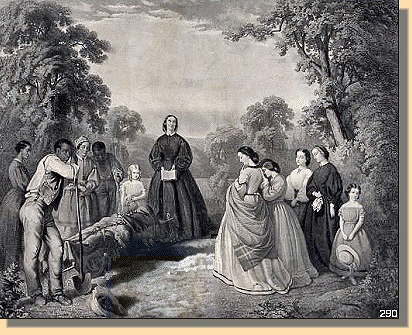
Burial of Latane by W.D. Washington ; engraved by A.G. Campbell.
(Library of Congress' copy of engraving damaged - Repaired by Ed.)
Engraving after a painting by William Dickinson Washington shows the funeral
of William D. Latan�, a cavalry captain who was the only Confederate killed
during J.E.B. Stuart's raid around the Union army near Richmond, Virginia on
June 13, 1862. The funeral on Summer Hill Plantation is attended entirely by
women, slaves and children. Mrs. Willoughby Newton performs the burial service
in the center while her sister, Mrs. William Brockenbrough stands with other
women and girls to the right. Slaves stand to the left.
|
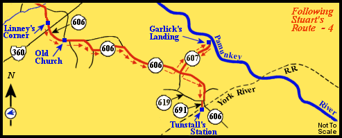
Route
(in red)
from Linney's Corner, upper
left, to Tunstall's Station, lower middle.
Following the Route Numbers:
Continuing down Route 606, we cross Route 360 at the stop lights. About a mile
and one-half past Route 360 we come to an intersection marked "Old
Church".
|
 (N) (N)
Old Church Tavern.
When Stuart arrived here, he had to decide whether to continue riding around
McClellan or return to Lee. He had already obtained the information Lee
requested.
... Here was the turning point of the expedition. Two routes were before me -
the one to return by Hanover Court-House, the other to pass
around through New Kent, taking the chances of having to swim the
Chickahominy and make a bold effort to cut the enemy's lines of communication.
The Chickahominy was believed by my guide to be fordable near
Forge Bridge. I was 14 miles from Hanover Court-House,
which I would have to pass. If I returned, the enemy had a much
shorter distance to pass to intercept me there; besides, the South Anna
was impassable, which still further narrowed the chances of escape in
that direction; the enemy, too, would naturally expect me to take that
route. These circumstances led me to look with more favor to my
favorite scheme, disclosed to you before starting, of passing around.
It was only 9 miles to Tunstall's Station, on the York River Railroad,
and that point once passed I felt little apprehension beyond. The route
was one of all others which I felt sure the enemy would never expect
me to take. On that side of the Chickahominy infantry could not
reach me before crossing, and I felt able to whip any cavalry force that
could be brought against me. Once on the Charles City side, I knew
you would, when aware of my position, if necessary, order a diversion
in my favor on the Charles City road, to prevent a move to intercept
me from the direction of White Oak
Swamp. Besides this, the hope of striking a serious blow at a boastful and
insolent foe, which would make him tremble in his shoes, made more agreeable
the alternative I chose. In a brief and frank interview with some of my
officers I disclosed my views, but while none accorded a full assent, all
assured me a hearty support in whatever I did.
With an abiding trust in God, and with such guarantees of success
as the two Lees and Martin and their devoted followers, this enterprise
I regarded as most promising. Taking care, therefore, more particularly,
after this resolve, to inquire of the citizens the distance and the
route to Hanover Court-House, 1 kept my horse's head steadily toward
Tunstall's Station ...
Following the Route Numbers:
Continuing on Route 606, Old Church Road, after about eight miles we turn left
onto Route 607, Steel Trap Road, a dirt and gravel road.
About a mile down Route 607, (which, at times, appears to be a lane in
somebody's back yard and is also marked with an "End State Maintenance"
road sign) we turn right and down a hill into the Garlick's Landing
parking lot.
|
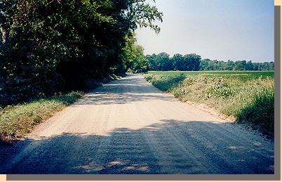 (O) (O)
Road to Garlick's Landing.
... There was something of the sublime in the implicit confidence and
unquestioning trust of the rank and file in a leader guiding them
straight, apparently, into the very jaws of the enemy, every step
appearing to them to diminish the faintest hope of extrication. Reports of
the enemy's strength at Garlick's and Tunstall's were conflicting, but
generally indicated a small number. Prisoners were captured at every
step, and including officers, soldiers, and negroes.
The rear now became of as much importance as the front, but the
duties of rear guard devolving upon the Jeff. Davis Legion, with the
howitzer attached, its
conduct was intrusted to its commander, Lieutenant-Colonel Martin, in whose
judgment and skill I had entire confidence. He was not attacked, but at one
time the enemy appeared in his rear bearing a flag of truce, and party, 25
in number, bearing it, actually surrendered to his rear guard, so great was
the consternation produced by our march. An assistant surgeon was also taken.
He was en route and not in charge of sick ...
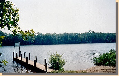 (P) (P)
Garlick's Landing.
... Upon arriving opposite Garlick's I ordered a squadron from the
Ninth Virginia Cavalry to destroy whatever could be found at the landing on
the Pamunkey. Two transports loaded with stores and a large number of wagons
were here burned, and the squadron rejoined the column with a large
number of prisoners, horses, and mules. A squadron of the First Virginia
Cavalry (Hammond's) assisted in this destruction ...
|
|


