
|
U. S. CIVIL WAR
PHOTOGRAPHS
|

|
JEB STUART'S RIDE
AROUND MCCLELLAN
(PAGE 2 of 11)
| |
Report of Brig. Gen. J. E. B. Stuart, C. S. Army, commanding Cavalry Brigade, with congratulatory orders.
HDQRs. CAV. BRIG., DEPT. OF NORTHERN VIRGINIA,
June 17, 1862.
GENERAL: In compliance with your written instructions I undertook
an expedition to the vicinity of the enemy's lines on the Pamunkey
with about 1,200 cavalry and a
section of the Stuart Horse Artillery.
The cavalry was composed of portions of the First, Fourth, and Ninth
Virginia Cavalry. The second named, having no field officer present,
was, for the time being, divided between the first and last mentioned,
commanded, respectively, by Col. Fitz. Lee and Col. W. H. Fitzhugh
Lee; also two squadrons of the Jeff. Davis Legion, commanded by
Lieut. Col. W. T. Martin, the section of artillery being commanded by
First Lieut. James Breathed.
Although the expedition was prosecuted farther than was contemplated in
your instructions I feel assured that the considerations which
actuated me will convince you that I did not depart from their spirit,
and that the boldness developed in the subsequent direction of the
march was the quintessence of prudence.
The destination of the expedition was kept a profound secret (so
essential to success) and was known to my command only as the actual
march developed it ...
(Source: O.R.-- SERIES I--VOLUME XI/1 [S# 12] - Throughout this section
portions of J.E.B. Stuart's report on his trip, as contained in the Official
Records, are shown in red font and italics, as above.)
LET'S START
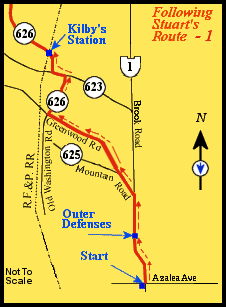
Route
(in red)
from the starting point, bottom
center, to Kilby's Station, upper left.
***
Following the Route Numbers:
(Throughout this section, these boxes will describe how to follow Stuart's
path using the present highway system...they describe the route highlighted
in the seven small maps provided in this section.)
To begin the tour, we go to the intersection of Brook Road (U.S. Route 1) and
Azalea Avenue north of the city. It was here that J.E.B. Stuart began his
famous ride.
Riding north on Brook Road for approximately .7 miles we come
to a stop light providing access to a shopping center on the left and some
fairly well preserved Richmond outer defenses earthworks.
For reference, on the right side of the road, at the light, there is a pull
over area that has three Virginia markers addressing the Richmond outer
defenses.
To visit the earthworks, turn left at the light and park in the shopping
center parking lot.
|
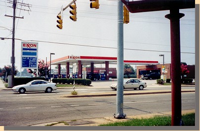 (A) (A)
Starting Point for Stuart's Ride.
The southwest corner of the intersection of Azlea and Brook roads in Richmond,
Virginia. This was the site of the Mordecai Farm, where Stuart started his
trip. (
All photographs in this section, other than 19th century
photographs, were taken in 2005
).
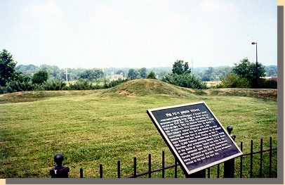 (B) (B)
Richmond's Outer Defenses.
Riding north on Telegraph Road (Currently named Brook Road, U.S. Route 1)
Stuart crossed Richmond's outer defenses near the site of these preserved
earthworks.
Route
(in red)
from the starting point, bottom
center, to Kilby's Station, upper left.
Following the Route Numbers:
Following Stuart, we continue north on Brook Road (U.S. 1) for approximately
two miles, then turn left onto Mountain Road, Route 625.
Approximately 1 mile down this road, we come to a fork at which Route 625 goes
to the left. We do not follow Route 625, rather we continue straight onto
Greenwood Road.
About three miles down Greenwood Road, we turn right onto
Old Washington Highway, Route 626; then, one and one-half miles later, we
turn left onto Route 623.
Finally, about a quarter mile down this road,
we turn right returning to Route 626. A half mile down Route 626 we arrive
at Kilby's Station.
|
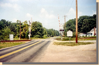 (C) (C)
Kilby's Station, now called Elmont.
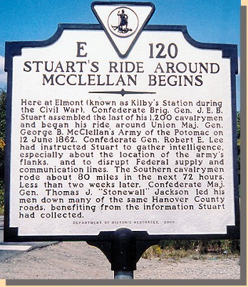 (C) (C)
State Road Sign at Kilby's Station.
At the time of Stuart's ride, Kilby's Station was being picketed by some
Virginia cavalry. Stuart picked up additional men here to accompany him on
his ride.
... The force was quietly concentrated beyond the Chickahominy, near Kilby's
Station, on the Richmond, Fredericksburg and Potomac Railroad, and moved
thence parallel to and to the left of that road. Scouts were kept far to the
right to ascertain the enemy's whereabouts, and advanced guard, flankers,
and rear guard to secure our column against surprise. I purposely directed
my first day's march toward Louisa, so as to favor the idea of re-enforcing
Jackson, and encamped just opposite Hanover Court-House, near South Anna Bridge
(Richmond, Fredericksburg and Potomac Railroad), 22 miles from Richmond ...
|
|
PAGE THREE
***
 The little
blue
arrow on the north directional arrow, on each of the numbered maps, is a
The little
blue
arrow on the north directional arrow, on each of the numbered maps, is a
"Richmond finder". It shows the direction to Richmond.
It can be used as a reference as you follow
Stuart's ride around McClellan.
 >
Civil War Photos
>
Stuart's Ride
>
2
>
3
>
4
>
5
>
6
>
7
>
8
>
9
>
10
>
11
>
Civil War Photos
>
Stuart's Ride
>
2
>
3
>
4
>
5
>
6
>
7
>
8
>
9
>
10
>
11
|
|
