We strive to provide accurate information about the Civil
War on this site, however our information is only as accurate as the sources that
we use. Consequently, although we believe the data contained in this site
is fully accurate, we cannot guarantee it.
We do not knowingly publish incorrect information and ask visitors to this
site who see an error to
contact us.
UP-TO-DATE
History is one item that tends to have endurance. Since you cannot change the
past, changes that occur are usually the result of newly discovered
information or modfications of presentation or access.
Because this site contains both current and old data, you might find some
differences in my visit to a battlefield several years ago compared to
your recent visit to the same battlefield.
But that is the nature of the beast.
Since we cannot devote a large part of our time to re-visiting battlefields,
especially those out-of-state, you can expect some minor differences between
our visit to a battlefield and your more current visit to the same battlefield.
Hopefully, the differences are not major.
As in the section above, we sincerely request that you let us know of any
changes or differences in our site compared to your experience.
PHOTOGRAPHS
A majority of the photographs on this site have been enhanced with "drop
shadows", the removal of "pot marks", etc. For additional information on
these "enhancements" see our Photographic
Information page.
MAPS
With the exception of 19th Century maps, all maps on this site are under
our copyright. (To access our maps go to the Maps page.)
The maps are not copies of any existing maps. Rather, they are our products
using a variety of sources and drawn in such a way as to best illustrate the
information that we wish to convey. The maps are not drawn to scale, rather,
they are close approximations of the battlefield layout and the locations of
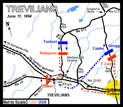
people or units. For example, look at the map of the Trevilian Station
Battlefield, June 11, 1864, below:
Trevilian Station Battlefield Map, June 11, 1864.
The map provides you with the relative troop locations and movements on June
11, 1864. It also illustrates the important locations regarding the battle
(ie. The "Netherland Tavern"). However it is not meant to be
a detailed layout of the battlefield or of the roads associated with it.
IN CONCLUSION
Please contact us if you have any problems with the accuracy or content of
this site.