
|
U. S. CIVIL WAR
PHOTOGRAPHS
|

|
THE WILDERNESS
(PAGE 4 OF 12)
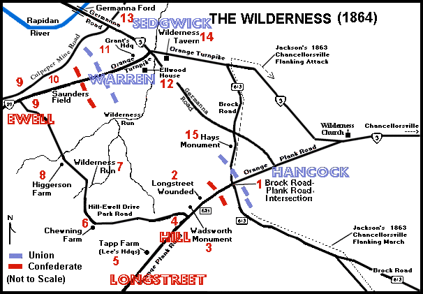 Click on a number on this map to see a photograph from that location.
The numbered locations on this map are shown in parentheses ( � ) in the text.
| |
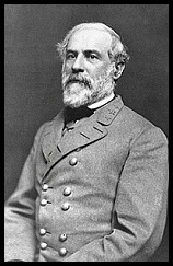
Gen. Robert E. Lee � 1
THE ARMY OF NORTHERN VIRGINIA'S LOCATION
When Lee received word, from signalmen on Clark's Mountain, of Grant's move into
the Wilderness, Confederate General Richard S. Ewell's Second Corps and General
Ambrose P. Hill's Third Corps were stationed near Orange Court House, about
twenty miles southwest of Grant's forces. General James Longstreet's First Corps
was more than ten miles farther away, at Gordonsville. Accordingly, Lee could
respond with the Second and Third Corps, but it would take longer for Longstreet
to bring up his First Corps.
|
|
 10
10
|
|
 99
99
|
|
 16
16
|
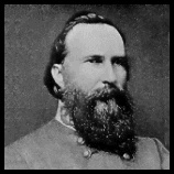
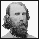
General James Longstreet
Confederate First Corps
|
|
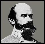
General Richard S. Ewell
Confederate Second Corps
|
|
General Ambrose P. Hill
Confederate Third Corps
|
| |
THE ARMY OF NOTHERN VIRGINIA MOVES
However, Lee did not hesitate. He immediately placed the Army of Northern
Virginia on the roads toward Grant. Ewell's Second Corps was sent northeast on
the Orange Turnpike while Lee went with Hill's Third Corps on the parallel
Orange Plank road. Longstreet was told to bring up his First Corps behind Hill
on the Orange Plank road, but, at his request, his Corps traveled on the
Catharpin Road, a third parallel road. Lee wanted no engagement until
Longstreet's Corps was present.
THE BATTLE BEGINS
On the morning of May 5, 1864, Ewell's Confederate force, moving northeast on the
Orange Turnpike, ran into Warren's Union Corps southeast of Germana Ford. Warren
had orders to attack, and heavy fighting ensued, on and around Saunders* Field
(10).
Thus started the battle of the Wilderness; a confusing and bloody battle which,
before it ended on May 7, 1864, cost both armies an estimated 29,800
casualties (USA 18,400; CSA 11,400) and resulted in
the deaths of Union generals James S. Wadsworth and Alexander Hays and
Confederate generals John M. Jones, Micah Jenkins, and Leroy A. Stafford. (USA 18,400; CSA 11,400) and resulted in
the deaths of Union generals James S. Wadsworth and Alexander Hays and
Confederate generals John M. Jones, Micah Jenkins, and Leroy A. Stafford.
| |
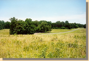
Saunders Field from south of the Orange Turnpike (10)
A grove of trees encircles the current National Park Service Visitors Shelter.
The road is State Route 20, the Orange Turnpike. The photograph was taken from
in front of the Ewell Earthworks, south of the Orange Turnpike (9).
|
|
| |
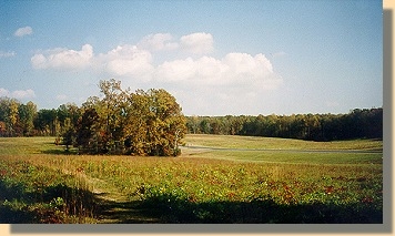
Saunders Field from north of the Orange Turnpike (10)
A different view of the grove of trees around the current National Park
Service Visitors Shelter. State Route 20, the Orange Turnpike, is on the
right. The photograph was taken from in front of the Ewell Earthworks,
north of the Orange Turnpike (9).
|
|
| |
Saunders Field and the 140th New York Monument. (10)
The photograph was taken from the N.P.S. Shelter facing toward the Ewell
Earthworks, north of the Orange Turnpike.
|
|
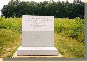
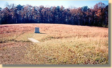
140th New York Monument in Saunders Field. (10)
140TH NEW YORK STATE VOLS.
FIRST BRIGADE, FIRST DIVISION, FIFTH CORPS.
NUMBER ENGAGED 529
CASUALTIES
23 KILLED, 118 WOUNDED,
114 MISSING
|
|
|
PAGE FIVE
* "Saunder's Field" is also known as "Sander's Field" and "Palmer's Field".
 >
Photos
>
The Wilderness
>
Page 2
>
3
>
4
>
5
>
6
>
7
>
8
>
9
>
10
>
11
>
12
>
Photos
>
The Wilderness
>
Page 2
>
3
>
4
>
5
>
6
>
7
>
8
>
9
>
10
>
11
>
12
Notes
|
|
